Printed Topo50 / 1:50,000 map sheets are available from Bivouac Outdoor, both online and in store.
![]()


NZ Topo Map is an interactive topographic map of New Zealand using the official LINZ's 1:50,000 / Topo50 and 1:250,000 / Topo250 maps.
Map last updated April 2025.
The following 3rd party apps are available allowing offline use of the topo maps:
This service wouldn't be possible without:
Service provided by Gavin Harriss. Need something similar? Get in contact.
If you are:
To send me an email use the form below.
A small donation
If you're finding the NZ Topo Map service useful please consider donating, no matter how small, it's greatly appreciated.
Why donate?
NZ Topo Map is developed and maintained in my spare time. Your donation will help cover the ongoing hosting and bandwidth costs required to keep this free service up and running. Donations also show your love and encourage me to development new functionality.
Thank you!
Cryptocurrency is also welcome.
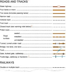
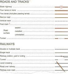
The following important information is taken directly from the maps legend:
All information and materials available at this web site are provided "as is" without any warranties of any kind, either express or implied, and NZ Topo Map disclaims all warranties of any kind, either express or implied, including warranties of merchantability, fitness for a particular purpose, non-infringement of intellectual property or arising from a course of dealing, usage or trade practice. NZ Topo Map reserves the right to remove any information from the web site at any time. In no event shall NZ Topo Map be liable for any damages whatsoever (including, without limitation, indirect, special, consequential or incidental damages or those resulting from lost profits, lost data or business interruption) arising out of the use, inability to use, or the results of use of this web site, any web sites linked to this web site, or the materials or information contained at any or all such web sites, whether based on warranty, contract, tort or any other legal theory and whether or not advised of the possibility of such damages. If your use of the materials or information on this web site results in the need for servicing, repair or correction of equipment or data, you assume all costs thereof.
NZ Topo Map strives to provide you with useful, accurate, and timely information on this web site. Accordingly, NZ Topo Map has attempted to provide accurate information and materials on this web site but assumes no responsibility for the accuracy and completeness of that information or materials. NZ Topo Map makes no commitment to update the information or materials on this web site which, as a result, may be out of date.
You can use the site without disclosing any personal information.
You may choose to disclose personal information to NZ Topo Map when you give feedback or in submission forms.
If you provide personal information, it's held by NZ Topo Map. Email addresses are not made available to the public. Unless required by law, NZ Topo Map won't publicise the names or email addresses of individuals who provide feedback or who use submission forms without their consent.
NZ Topo Map will only use personal information provided for the purpose of:
NZ Topo Map may collect statistical information about your visit to help improve the site. This information is aggregated and doesn't identify you personally. It includes:
This site generates persistent session cookies (that is, they have an expiry date and are removed on that date) for the purpose of monitoring site usage. The cookies don't collect personal information. You can disable them or clear them out of your web browser without affecting your ability to use the site.
It looks like you have an ad blocker installed.
NZ Topo Map relies heavily on advertising revenue to cover its ongoing hosting and bandwidth costs.
If you'd like to see the continued survival of this free service, please consider adding NZ Topo Map to the whitelist of your ad blocker.
Better still, make a donation:
Cryptocurrency is also welcome: